

It began, however, as part of a huge tract that belonged to Will Stone, who, like Henry Mounger, Hugh Ross, and the Crump Brothers, John and James, then sold it in 100 acres lots to other settlers coming into the area from Virginia, Pennsylvania and more northern counties of North Carolina like Warren, Franklin and Chatham.

John Ozier 100 acres Warrant #7348 Issued Feb 1, 1816 by Will Stone to John Ozier for 100 acres on the West side of Rocky Creek (Rock Creek that most Stanly Countians will be familiar with because of Rock Creek Park), and joins a hill called Wolf Mountain.; entered Oct 30, 1815. 100 acres surveyed June 18, 1816 by David Cochran, on West side of Rocky Creek, border begins at John Birds corner Blackjack, Tinch Carter and Allen Ozier, chain carriers.
The Ozier family is not one that I am familiar with. They did not leave a significant mark on Stanly County, but herein two of them are named, John and Allen.
John Ozier first shows up in 1800 census for Montgomery County, NC (keep in mind Stanly County is still part of Montgomery at this point, until 1841). He is not the only Ozier. Also listed is William, Jacob and William Jr.
In 1810, he is still here, living near McCorkles and Greens. There is no 1820 census for Montgomery County. It was lost or burned. In 1830, John Ozier is still in Montgomery County, on the future Stanly County side, living right next to a Jeremiah Ozier. Other neighbors were Edward Slaughter, Tyron Morris, Tobias Kendrick, Martin Hill, Seth Andrews and Marmaduke Hogan. If none of those names, with the exception of Seth Andrews, it is because they all belong to a huge swath of people who migrated to Tennesee in the 1830's.
The Oziers were a very interesting family. A William Ozier was the first one to show up in the 1790 census. According to an Obituary for Jacob Ozier Jr., a son of Jacob Ozier Sr. and a grandson of William, he was born in Montgomery County, North Carolina. His family was of French Hugenot origin. John, who lived in what turns out to be the area currently occupied by Walmart and Hobby Lobby in Albemarle now, was the Uncle of this Rev. Jacob. While Jacob Sr. moved to Alabama and Georgia, John and Allen, (who turns out to be his son), end up with a lot of their Stanly (Montgomery County) neighbors in Carroll County, Tennesee.
William Ozier Sr. first filed a land grant in Montgomery County on May 16, 1792 on the "North East Side of the Pee Dee River. He was also listed in a 1787 Tax List, so the family arrived her quite early.

| Name: | William Osher [William Ozier] | ||||||||||||||||||||||||||||||||||||||||||||||||||||
|---|---|---|---|---|---|---|---|---|---|---|---|---|---|---|---|---|---|---|---|---|---|---|---|---|---|---|---|---|---|---|---|---|---|---|---|---|---|---|---|---|---|---|---|---|---|---|---|---|---|---|---|---|---|
| State: | NC | ||||||||||||||||||||||||||||||||||||||||||||||||||||
| County: | Montgomery County | ||||||||||||||||||||||||||||||||||||||||||||||||||||
| Township: | District #2 | ||||||||||||||||||||||||||||||||||||||||||||||||||||
| Year: | 1787 | ||||||||||||||||||||||||||||||||||||||||||||||||||||
| Record Type: | State or colonial census | ||||||||||||||||||||||||||||||||||||||||||||||||||||
| Page: | 001 | ||||||||||||||||||||||||||||||||||||||||||||||||||||
| Database: | NC Early Census Index John Ozier is listed in the 1829 Will of Samuel Parker of Montgomery County.  John himself was issued 5 Land Grants. The first, in 1797 was listed as being on "Mountain Branch" and consisted of 50 acres.
 The second, entered June 21, 1800 and issued May 12, 1804 is for 50 acres "on the banks of a branch".
The third, this one 100 acres, is "on the West Side of Rocky Creek" and was issued 17 years later. John is now up to 100 acres. He continues to prosper. A month later, he enters another 100 acres on the "East Side of Rocky Creek". John Ozier pretty much has Rock Creek sewed up.
In January of 1818, just two months later, he makes his largest acquirement to date, 400 acres. Add that to the 300 he has already accumulated and John Ozier has 700 acres, that takes him all the way up to Wolf Mountain. But where exactly is Wolf Mountain? Another deed, dated Nov 24, 1835 states: " David Laton 100 acres, warrant 11097 issued July 7, 1835 by Duncan McRae to David Laton for 100 acres joins Wolf Mountain "OWNERS OF GRANTED LAND NOT KNOWN" on waters of Jacobs Creek, entered Aug 24, 1835 100 acres surveyed Dec 21, 1836 by Joseph Cauble, border begins at Huckabee's corner black jack, crosses Morganton Road & joins William Ragsdale. John Laton and Baily Sanders, Chain Carriers. The sons of John Ozier show up in the 1836 and 1839 Tax Lists of Carroll County, Tennesee. Some of them show up in the 1830 census. So does a John Ozier who was born between 1770 and 1780. The John Ozier who shows up in the 1830 census of Montgomery County was born between 1790 and 1800. He has a wife and 4 small children in the home, along with 2 old ladies, one in her 70's and another in her 80's.
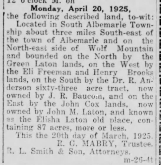
There is also a William Ozier nearby, probably William Jr. This John is obviously too young to have recieved the land grants. He is probably a nephew of the older John. I believe the older John to have left for Tennessee sometime in the 1820's. This younger John might have even been his son, and stayed behind to take care of the older female relatives, but neither he nor the younger William remained until 1840. So, we know that by 1840, the Oziers were gone and Wolf Mountain was occupied around by Laton's and William Ragsdale. Stanly County land records begin in 1841 and there is no William Ragsdale, but his land appears to have transferred to Timothy Ragsdale, who I know died in the Civil War. In December of 1850, Timothy Ragsdale sold a tract of land to Eben Hearne for debts owed that bordered John Laton, James Palmer and Isham Talbert. It appears to be in the same area as the William Ragsdale land would have been. The below notice from 1925 mentions a tract of land on the North-East side of Wolf Mountain and located 3 miles Southeast of Albemarle. Remember, at this time, the town of Albemarle was pretty much only what we would count as the center of downtown and the nearest neighborhoods thereinto. Notice that among the names mentioned is John Laton, and other Latons. It also bordered the land of Dr. Richard Anderson, which gives a huge clue as to the exact location of Wolf Mountain. |
The Albemarle Press
(Albemarle, North Carolina)26 Mar 1925, Thu • Page 7

I found Wolf Mountain on an old map. It lay south of the Anderson Heights area and east of the old Albemarle Airport, where Walmart and Olive Place shopping centers now exist. With this information I went looking both in person and on modern Topographical maps and found Wolf Mountain. It lies east of Groves Road and the foot of it marks the beginning of Stonehaven Development. Yorkshire Drive climbs up its eastside.
Some folks found the relatively unoccupied hill a good place to make alchohol and have fun. Unfortunately for them, the cops found them out.
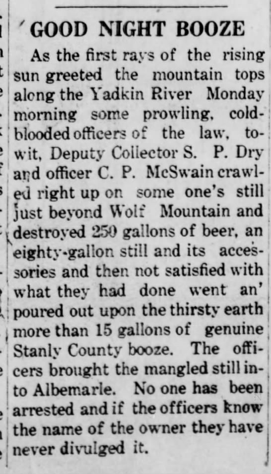
Stanly County Herald
(Albemarle, North Carolina)10 Jul 1919, Thu • Page 1
Wolf Mountain is located just beyond Anderson Heights, which was part of the old lands and farm of Dr. Richard Anderson, who deeded Anderson Grove Baptist Church to the Congregation and whose name the Anderson Grove area still bears. It has been wholey unoccupied until just recently, when additions to the Housing Development have started to climb up its Southeastern side.

The above dirt road climbs to the top of Wolf Mountain. I did not go there. You can see the landscape in the distance. Wolf Mountain lies behind Walmart, less than half a mile. Groves Road is the closest to it on the south side, at the foot.

Looking out from the side of Wolf Mountain toward Albemarle. All you see is hills and woods.

The housing development at the base of Wolf Mountain. Yorkshire Drive crawls up the side.

From the pool house at the beginning of Stovehaven Drive, you can see Wolf Mountain rise in the background.

Beyond the pavement, the road climbs.

Looking out toward Albemarle and the foothills of the Uwharreis.
No comments:
Post a Comment