
I first met Lowder Mountain when viewing the below picture from the Stanly County History Center, presented by Lewis Bramlett, who issues a daily Facebook post for the Center. I grew up in Albemarle, and had never heard of Lowder Mountain, yet here it was, easily seen from the top of the hill that is the square of Albemarle, the intersection of Main and Second Streets. Over the past several years, I have spent hour upon hour perusing old deeds and newspapers, researching this family or that one either I or my children (via their two fathers) are descended from. Often, I have encountered the mention of this creek or that mountain, some branch or ridge, that I had never heard of. These geographical features had been mapped within the political boundaries of Stanly County, but their names had been lost to modern generations. Thus begins my endeavor to give them their names back. But where are they?
 |
| Post Card of Albemarle dated 1907, Courtesy of Lewis Bramlett and the Stanly County History Center |
The above 1907 Postcard is labeled "Lowder Mountain looking west - Albemarle, NC". The building under the red arrow was built in 1903 and sits at the corner of First Street and West Main Street. It's popularly known as the old Roses building and currently holds Top Dollar Pawn Shop.
 |
| A modern view of Lowder Mountain from the Albemarle Square |
Lowder Mountain and a few other small mountains, while still considered part of the Uwharrie Range, arise not from the banks of the Uwharrie or Yadkin River, as most of the other Uwharries do, but are actually part of a group of hills that rise up in peaks and ridges from Long Creek, the longest and widest creek in the county not named as a river. In places, it rivals the river it feeds into, the Rocky River.
 |
| Long Creek as seen from the Charlotte Road/West Main Street, Albemarle |
Long Creek is fed by various other small creeks and branches, that roll off a myriad of springs and culverts from the higher elevations in the northern part of the county. I had long heard that the New London area was the highest elevation in the country and it appears these high grounds give birth to Long Creek, which runs through Albemarle all the way to Rock River.
 |
| Looking down on Long Creek from Central Avenue |
Long Creek winds from City Lake Park through the western part of town. This old watery snake has created steep banks, long ridges and high braes in it's wake. In old records, I've entercountered several named Mountains in its family, several I have not determined their location, Long Creek Mountain, Lowder Mountain, Nelson Mountain, Burns Mountain, Thomison's Mountain, Adderton's Peak, Pennington's Ridge, Poplin's Point, Hearne's Hill. Some might have a familiar ring, while others are complete question mark.
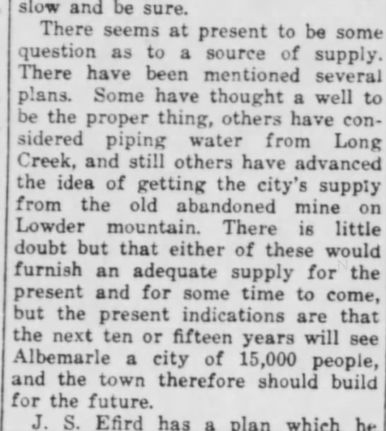
Pouring through old deeds, I see mentions of land that involve the Lowder Gold mine. It sat at the foot of Lowder Mountain. I knew from the descriptions of the Gold Mine, that if I could locate it, I should find the mountain rising above it.

The above is a photograph of a turn-of-the-century map in glass, thus the glare. On the left in tan, is an area that was known as "Burleson". The area or community of Burleson encompasses an area from the beginning of St. Martin Road, at it's Albemarle origins, across the Charlotte Road and down Canton Road from it's Albemarle end. It's a vast area covered in Burlesons. It adjoined the Lowder lands. In green, just above the "A" that spelled "Albemarle", you can see the name "T. F. Lowder" whose home sat on a road that looped and connected to the Concord Road, up above it in red. To the west of T. F. Lowder is a Miller and an another Lowder, whose house was on the same road as the Miller and right on Long Creek. That road, from what I can gather from deeds and newspaper articles was called Lowder Road. It connected to the Charlotte Road, that can be seen at the bottom of the picture in red. Also above the "A" and the road that "loops" to Concord Road is a little cross that marks the location of a Gold Mine. That was Lowder's mine.
The mine is mentioned in an article in The Enterprise as a possible source of the city's water supply.
The Enterprise
(Albemarle, North Carolina)23 Nov 1911, Thu • Page 4
I had now gathered enough information to determine the whereabouts of Lowder Mountain. How can you not know where a mountain is, some may ask? It's a mountain. Well, Albemarle itself sets on several high hills. There are hills, valleys, ridges, all around. Stanly County, especially near its multiple waterways, is full of these hills. The names of these hills, once referred to as mountains, has been lost to time. We drive down the roads that go between them, and seldom go up them and tend to really not pay attention to them, except in autumn, when they turn into colorful patchwork ramparts against the sky.
Now that I am actively searching for them and acknowledging them, I am pointing them out to my children and grandchildren. We'll crest a hill where the view is clear, and I will point, "What is that?" They look, and lo and behold, "It's a mountain." And they really never noticed it was there. Because like Lowder's Mountain, roads cut all around the base of it, but until sometime in the 1980's, none went up the sides of it, and none yet to it's peak. But someone decided to build a school onto the side of it, and a housing developement climbing up that same side now.
The things I had first determined about Lowder Mountain was:
1) It lay west of Albemarle.
2) It's name derived from Thomas A. Lowder and his descendants.
3) It lie between the Concord (73) and Charlotte (West Main/24/27) Roads. Although the exact trajectories of the roads have ebbed and flowed over the decades, the general direction has not.
Traditional oral Lowder family history maintains that two brothers, Thomas and William Henry, came from Pennsylvania to what is now Stanly County during the later half of the 1700's. Some add a third brother, who supposedly settled in the Canton area. Thomas settled on Long Creek and William settled on Bear Creek. Our focus is on Thomas and the Long Creek area. He acquired a massive amount of land in his time. Not much of it was "developed", but he owned it. I found a total of 6 grants in his name. The grants are listed in Montgomery County as Stanly was part of Montgomery at the time.
The first 2, Grants Number 1596 & 1597, were entries numbered 4015 and 4016 and entered on August 21, 1797, Book 101 Pages 259 & 260. There descriptions only as being on the South West side of the Yadkin River. I discovered that the terms "on ___ side of ___ River" does NOT mean the land adjoined the river. It simply meant that the tract lay within the named county on that certain side of the river. It could be 15 miles away, just depending on how wide or long the county was, it could be 50 miles away, or before the counties were subdivided, even further depending how far one river was from another.
The third grant came 4 years later on January 31, 1801, Entry number 5549, for 300 acres, described simply as "Beginning at a small pine".
Two more came later that year, both on August 24, 1801, Entry numbers 5660 and 5661. 5660 was for 50 acres " Beginning at a pine on top of a hill" and 5661 was for 100 acres "Beginning at a post oak."
The last grant was # 2841, entered on December 17, 1828 for 200 acres located "6 miles South West of the Pee Dee River".

Thomas Lowder and wife, Elizabeth, are buried at the Old Freedom Cemetery, which is located down St. Martin Road about 3 miles out of Albemarle.
In 1828, Thomas Lowder granted to his children tract to certain portions of his land, these tracts, so large themselves, show the massive amount of land he owned and controled. It is commonly accepted that he had 6 children to live to adulthood, 3 sons: George, Daniel and Samuel and 3 daughters, Amy (Mrs Benjamin Franklin Cagle), Catherine "Caty" (Mrs. Jesse Poplin), and Rebecca (Mrs. Brian Deese) .
Portions of this land encompassed certain portions of Lowder Mountain, his children settling round about its feet. These tracts were given with the "natural love, good will and affection" Thomas Lowder had for his children.
Amy Cagle, in Book 2, page 109, was given a tract on 'both sides of Long Creek", part of a 300 acre tract deed James Pickett and William Coleman on July 25, 1774, in line with the Lee tract.
Caty Poplin, in Book 2, page 110, was also given a portion of the tract orginally granted James Pickett and William Coleman, her borders and angles marked by sweet gums, black gums, white oaks and dogwoods, elms and hickory's, meetine Amy Cagle's corner.
 |
| Lowder Mountain as seen from Hedge Road |
Warrant 403 Granted to James Pickett and William Coleman in Anson County, NC (remember that at this time, what we now know as Montgomery and Stanly was part of Anson)
"You are forthwith to admeasure and lay out or cause to be admeasured and laid out a Plantation containing 640 acres of land in the county of Anson on Jones Creek joining Thomas Bailey's land on the Southwest side of the PeeDee river'. Given at New Bern on May 21, 1773
Warrant 406 lists 300 acres on the South West side of the PeeDee River and Long Creek on Camp Branch that runs into the Cloverfork Branch of Long Creek.
These are only two of 7 Grants James Pickett and William Coleman were given in what is now Stanly County. William Coleman, at least, also lived here as his name appears on a 1770 petition to divide Montgomery from Anson.
 |
| Lowder Mountain as seen from Poplins Grove |
So sisters Amy Lowder Cagle and Caty Lowder Poplin shared adjoining properties, sharing portions of a tract originally granted James Pickett and William Coleman in 1774.

On this 1968 map of Albemarle, locate Long Lake in the upper left hand corner. The lands of Amy Lowder Cagle and Caty Lowder Poplin both lay south of Long Lake, west of Albemarle. The connection of roads that start just north of the bridge at Hwy 73 at the top of Long Lake (a), goes around it and at the bottom of the lake (b), connects to another road that follows a trajectory south (c) are City Lake Drive (a and b), with the straight offshoot being Bobcat Drive and Poplin Grove Church Road, which connects to West Main Street before West Main intersects with the Hwy 24/27 Bypass.

Amy Cagle (1795-1848) is said to be buried at the Cagle Confederate Cemetery, which is located near the interection of Poplins Grove road and Kingsley Drive, not far from the old City Lake dam

This view shows how close the Cagle Cemetery, which is on part of the old Thomas Lowder property, was to this section of Long Creek. Cemetery is on the left, Kingsley Drive is on the right side of the photo. The green sign on the right side of the road marks Long Creek at the Albemarle City limits and just beyond is the bridge over Long Creek.
Caty Lowder Poplin is said to be buried at Poplins Grove Church, which is near the Poplins Grove Church Roads intersection with West Main Street.

Poplins Grove looks like a modern church and from the road, looks like it has a fairly small, modern cemetery. Information states that the church was constituted on May 28, 1939.
 |
| A portion of Poplin's Grove Cemetery |
Upon closer inspection, the cemetery is much larger than the view from the road, and the graves are far, far older than the church itself. It's highly likely that is was a family or community cemetery long before the church was built and that the community was largely made up of descendants of Caty Lowder Poplin and her husband B. F. Poplin, thus the name "Poplins Grove".
 |
| This old marker is thought to mark the grave of Caty Lowder Poplin |
 |
| The size and age of this cemetery is very misleading from the view from the road. |
 |
| Gravestone of Isaac Lowder |
 |
| Marker of David T. Lowder with marker of Henry Lowder and wife in the upper left corner. |
 |
| Poplins' Grove is full of unmarked graves. Here, the graves are clearly laid out and spotted, but the markers have long eroded away and gone. |
 |
| Many Lowder family members are buried here. This is the grave of Sophia Lowder Morton (1839-1931) daughter of Samuel and Nancy Marbry Lowder, wife of Rev. William Green Morton and granddaughter of Thomas Lowder. |
Thomas Lowder Family Tree and Will
Of the three sons of Thomas Lowder, George Lowder (1788-1883) married Elizabeth Adderton and his buried with his parents at Old Freedom Cemetery. Elizabeth was the daughter of Jeremiah Adderton, who appears in early Maryland records with the Lowder brothers and seems to have traveled to North Carolina with them.
Daniel Lowder (1800-1881) and his wife Elizabeth Harwood Lowder are buried at Poplins Grove with his sister Caty Lowder Poplin.
Samuel Lowder (1808-1885) and his wife Nancy Marbury Lowder are buried at Old Freedom with George and their parents.
Youngest daughter, Rebecca M Lowder would migrate to Tallahatchie Mississippi with the family of her husband, Bryant Dees, who had been born in Chesterfield County, South Carolina. It is assumed she died in Tallahatchie.
In the Stanly County deeds, Book 3, Page 55, Bryant (or Brian) and Rebecca are seen selling their portion of Thomas Lowder's land to Nelson Pennington. This section of land encompassed another neighboring lump in the Stanly landscape to Lowder Mountain and this one would become known thereafter as "Nelson's Mountain".
The Enterprise
(Albemarle, North Carolina)
• Page 1
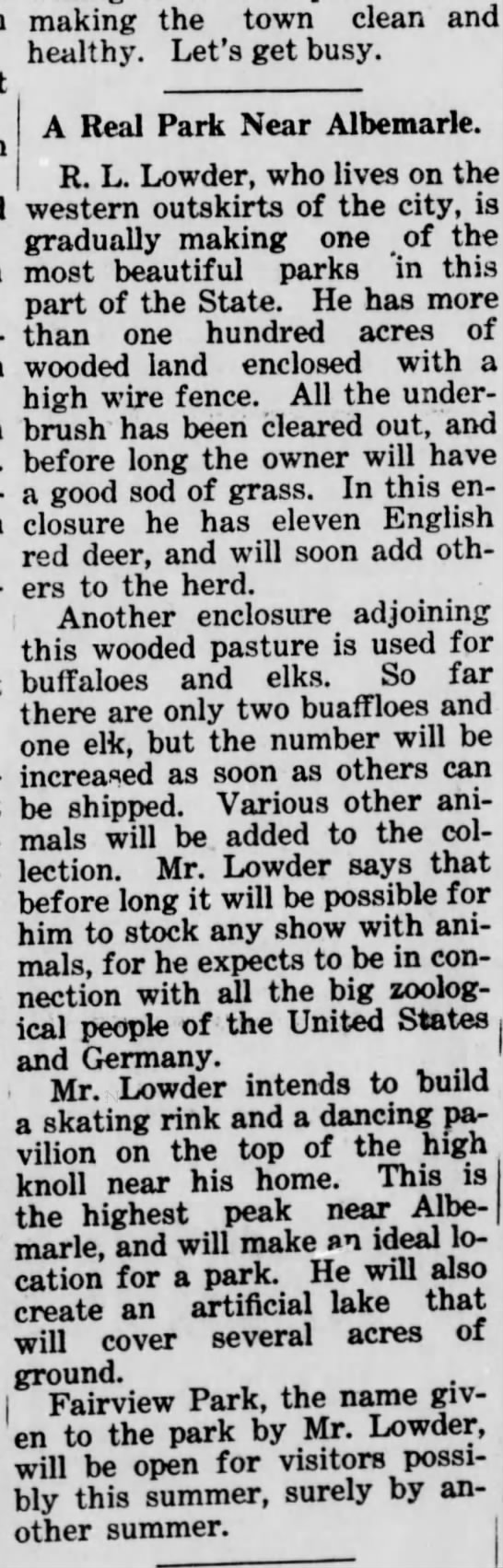
In the early part of the 20th century R. L. Lowder planned to open a park for local residents as he already owned a number of exotic animals. Less than a decade later, he sold this property and auctioned it off in 1922 before moving to Virginia.
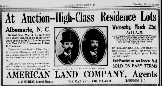
The Stanly News-Herald
(Albemarle, North Carolina) • Page 6
These lots became the area located in front of the old West Albemarle School and the old R. L.Lowder house still stands. The streets were named for the trees listed in the Lowder deeds, White Oak, Hickory, Cedar, Maple and Holly, with crossover streets, Forest and Brookwood.

Thomas Lowder
With the evidence presented, it appears Lowder Mountain was in the center of Thomas Lowder's massive land holdings just west of present day Albemarle.
Lowder's Mountain is shaped roughly like a fat "L" with the top of the L beginning and the head of Long Lake (or City Lake). Hatley Farm road crosses its northern foot. It's east of Burleson road and lies between Burleson road and the lake. Canton Road runs south of it and several roads from Cantons southern end run toward it, and dead end. Hedge and Crystal stop short of the rise, but Imperial Way and Northlake trail begin to climb it. Very close to these, College Drive also climbs the southern border of the "L" and Stanly Community College sits along the side of Lowder Mountain, but its highest points are west of there. A housing development climbs the same side as the college, connecting to Poplins Grove Church Road, which sits at the foot of it and runs to meet the bottom of the lake.
 |
| Albemarle circa 1930's, Lowder Mountain in the background. |
No comments:
Post a Comment