While posting about my fourth Great Grandparents, it really bothered me that I knew almost nothing about my fourth Great Grandmother, Patsy Atkins, who married James Palmer.
I knew she was born on December 20, 1784, due to well-kept Palmer Family Bibles. I know she died on July 18, 1879 and was buried at Kendall's Baptist Church, near New London, NC.
I knew she was the mother of 9 children with her husband James Palmer:
1) Little Lucy Palmer, who died at age 6, born June 9, 1808 - Aug. 14, 1814).
2) Mary Palmer, born November 17, 1809 and married Bailey F. Smith.
3) William Pearson Palmer, born November 1, 1811 and died February 19, 1881, who married Hannah Bushrod Harris.
4) Martha Palmer, born June 1, 1817 and died March 27, 1863, who married Henry Davis - my line.
5) Elizabeth Palmer, born August 18, 1818 and died on November 20, 1827, at the age of 9.
6) Serlana Palmer, born March 31, 1819 and died March 16, 1823, at the age of 3.
7) Sarah Palmer, born April 21, 1821 and died August 2, 1854, who married Richmond Gage Davidson Pickler.
8) Margaret Tyson Palmer, born April 8, 1834 and died February 24, 1879, who married Jonah Askew Love.
Page from Bible of W. P Palmer
I knew she appeared in three census records in Stanly County: 1850, where she and James are living the the "Albemarle Post Office" area, and have a 50 year old man in their home "Abia", who was labeled an idiot. The 1860, where James is 75 and Martha is 76 and they are living next to what appears to be a "Poor House", because everyone listed in it were Paupers. And the 1870, their last, where James is 85 and Martha is 86 and they are still in Albemarle Post Office and living near Kendalls and Calloways, and Laton's and Freemans, and surrounded by a bevy of Civil War Widows, Sarah Byrd, Amy Pennington, Elizabeth Smith, and Elizabeth Hinson. Also, in a separate house on the same property were Ralph Palmer, 58, and Adaline Palmer, 21. These two were African-American, signified by a "B" for race, and can be logically assumed to have been freed slaves of the Palmers, as they are shown in previous census records as being slave holders.
Page from Family Bible of W. P. Palmer
The Palmers lived long lives and had made it through the War. James, who had served in the War of 1812, lived to be 87 and passed away in 1873, and Martha, a year older than her husband, outlived him by 6 years and lived to be 94.
Kendall's Baptist Church, Kendall Valley area, Stanly County, NC
I have posted in this blog about her before in my 30 Mothers in 30 Days series, which I did for Mother's Day one year when I was stuck home recovering from an injury.
But I can not tell you where she came from, except that the census recors indicate she was born in North Carolina, or who her parents were. It's time to fix that, or try.
Martha's last child, Margaret Tyson Palmer, was a menapause baby, born when her mother was 50 years old and 13 years after her closest sibling, Sarah. Some may argue that she was probably a grandchild, but her brother, William Pearson Palmer, the only son, faithfully recorded all of the births and deaths of his siblings, except for the death of Mary, and Margaret was recorded as sibling.
Although she is not named, Martha can be regarded as the adult female in the older, dash-indicated census records, with her husband, James.
1830
Name
James Palmer
Home in 1830 (City, County, State)
West Side Pee Dee River, Montgomery, North Carolina
Free White Persons - Males - 20 thru 29
1 William would have been 19
Free White Persons - Males - 40 thru 49
1 James
Free White Persons - Females - 5 thru 9
2 Sarah and Serlana
Free White Persons - Females - 15 thru 19
2 Mary and Martha
Free White Persons - Females - 40 thru 49
1 Martha
Slaves - Males - Under 10
1
Slaves - Males - 10 thru 23
1
Slaves - Males - 36 thru 54
1
Slaves - Females - 10 thru 23
1
Free White Persons - Under 20
4
Free White Persons - 20 thru 49
3
Total Free White Persons
7
Total Slaves
4
Total - All Persons (Free White, Slaves, Free Colored)
11
1840
Name
James Palmer
Residence Date
1840
Home in 1840 (City, County, State)
West Pee Dee River, Montgomery, North Carolina
Free White Persons - Males - 40 thru 49
1 Abia?
Free White Persons - Males - 50 thru 59
1 James
Free White Persons - Females - 15 thru 19
1 Margaret or Sarah? Sarah would have been 18 or 19, Margaret only 7
Free White Persons - Females - 50 thru 59
1 Martha
Slaves - Males - 24 thru 35
1
Slaves - Females - Under 10
3
Slaves - Females - 10 thru 23
1
Slaves - Females - 24 thru 35
1
Persons Employed in Agriculture
4
Free White Persons - Under 20
1
Free White Persons - 20 thru 49
1
Total Free White Persons
4
Total Slaves
6
Total All Persons - Free White, Free Colored, Slaves
10
In the 1840 census, Margaret should have been around 7, and this is not found in the dashes, so there could have been other circumstances, but who was the other teenaged girl, if not Margaret and where did Margaret come from then? There have been mistakes in census records and ages, particularly among females. I've seen women buried with a year of birth 7 or 8 years younger than a census they show up in as a child. One in particular that I am thinking of, claimed a birth year of 1862, when she clearly showed up as a 5 year old in 1860 and a 14 year old in 1870.
Page from Bible of W. P. Palmer showing death dates of sisters.
In the early records of Montgomery County, NC, there were several records of Atkins, primarily James, John and Lewis. John, in particular, is mentioned in a large number of land records. But for the most part, they all disapear. Almost. By 1830, there are three others, George, John C. and Mary. The 1830 census is divided into East Pee Dee and West Pee Dee, depending upon which side of the Yadkin - Pee Dee River they lived upon. East Pee Dee was what would remain as Montgomery after the 1841 split and West Pee Dee would become Stanly.
George was in Stanly, living near Drury and Mark Morgan, who lived along the Rocky River below Oakboro and Stanfield. He was in his 50's, his wife in her 40's and they appeared to have 4 sons and 4 daughters.
Mary Atkins was in East Pee Dee, near James Hurley Sr., Thomas Ragsdale and Green Hardister. I know Thomas Ragsdale lived in "Lovejoy". Probably a widow, the oldest female in the home was in her 50's, probably Mary. Two boys, one under 5 and one between 5 and 10, a female between 10 and 15 and another between 15 and 20 lived with her. She also was counted with two very elderly slaves, a man and a woman, between 90 and 100, in her home. She also lived next to a widow Davis.
John C. Atkins was also in East Pee Dee, listed between Edmund Deberry and William Davis, or the Pee Dee area. He was in his 30's with a female 10 to 20, (perhaps a teenaged wife, and a teenaged boy as well, perhaps a farm hand.
All of them were gone by 1840. No Atkins (or Adkins as it was sometimes spelled), in Montgomery .
As there are really no (or few) records of Atkins in Stanly County, I've had to look in the Palmer family records for any mention.
Of interest, on October 17, 1844, Barbara Pickler swore out a warrant for the arrest of Ralph, a slave of James Palmer, for breaking into her barn and taking a bushel of wheat. Barbara (or Barbary) Pickler was the mother of Richmond Gates (or Gage) Davidson Pickler, who married James Palmer's daughter Sarah. The Picklers were somehow related to and entangled with the Davis family. For one, Henry Davis married Sarah's sister Martha. Henry's younger brother, Marriott Freeman Davis, would marry R.G.D. Pickler's sister, Mary, after she was widowed by the death Henry and M. F.'s first cousin, Milton Winfield. Yet, oddest of all, the four Davis brothers recieved an inheritance from R. D. G. Pickler's grandmother, Jane Davis Pickler, mother of his father, John Davis Pickler. That one I've not figured out yet, except for the Davis name.
In the above snippet from the 1830 census, you can see Barbary Pickler lived pretty close to George Atkins.
In another interesting court case, on May 10, 1852, James Palmer to become the guardians of Abia and James Atkins, both called idiots. the archaeic term for mentally incapacitated individuals.
In the 1850 Stanly County census, its first, James and Martha Atkins Palmer are in their 60's and shown with a 50 year old "Abia" in the home.
Name
James Palmer
Gender
Male
Race
White
Residence Age
64
Birth Date
abt 1786
Birthplace
North Carolina
Residence Date
1850
Home in 1850
Albemarle, Stanly, North Carolina, USA
Occupation
Farmer
Industry
Agriculture
Real Estate
300
Line Number
29
Dwelling Number
863
Family Number
868
Inferred Spouse
Martha Palmer
Household members
Name
Age
James Palmer
64
Martha Palmer
65
Abia Palmer
50
As far out to the left, Abia was noted as an 'idiot' in the last column, this must have been Abia Atkins, not Palmer. But where was James?
The next census, in 1860 shows James and Martha, now in their 70's, living next to a "home" headed by 75 year old Polly Yates, among the persons in her household was 55 year old James Atkins. Out to the left, all of these individuals were listes as "Paupers". This must have been the Poor House. It has been passed down in the family that James and Martha's farm was on the Salisbury Road, Old Salisbury Road now, on the hill where the old County Home was. The Poor House was a precursor to the County Home. Abia was not in the 1860 census and neither was in the 1870. It's unknown where James Atkins was in 1850.
So who were James and Abia in relation to Martha Atkins Palmer?
There was another Abia, an older Abia, who, like most of the other Atkins from early Montgomery and Anson, who had moved to Tennessee. The name ran in the family.
Speaking of names, there's other possible hints among the names. Howell Parker (Jr.), who is listed next to the Palmers, had a son named "Dr. Franklin". The name was passed down as his son Arnold, also had a Dr. Franklin. Sarah Palmer and her husband R. G. D. Pickler also named a son Dr. Franklin. Margaret Palmer and husband Jonah Love also had a son named Dr. Franklin. They also had a son named Mumford Parker Love.
Who was Dr. Franklin, the original? Were they referring to Ben? Was there a familial relationship between the Parkers and the Palmers, or the Parkers and the Atkins? And Margaret's middle name, Tyson, that's an odd middle name for a female, could Tyson be a family name up the line? And not knowing if Margaret was actually a daughter, or a grandchild raised by ther grandparents, could she have been a Tyson on her other parents side if she were?
Another odd middle name for females in this family was Baldwin. I've often wondered why Henry and Martha Palmer Davis had named a daughter Nancy Baldwin Davis. I know it runs in the Palmer side, because there are other females in that line with the middle name Baldwin. Was this a female ancestor up the line somewhere?
But the ultimate name that made me wonder is the one Atkins who stayed in Stanly County, the Rev. Athur Freeman Atkins. Not only has the "Arthur Freeman" plagued me for years, but also, he was an Atkins. Arthur Freeman of Virginia, is my 6th Great Grandfather, father of Charlotte Freeman Winfield and Great Grandfather of Henry Davis who married Martha Palmer daughter of Patsy Atkins Palmer.
There were several "Arthur Freeman" (insert surnames) among his grandchildren and great grandchildren. Was A.F. Atkins among them? I mean, in my years of digging, I've noticed these groups of connected families were more apt to marry within their own group and even own family, than they were to marry a stranger.
Among the tidbits in the Palmer files is this one, from a letter of a granddaughter of William Pearson Palmer, James and Patsy's only son. Her statement was "Grandpa Billie and Arthur were first cousins". She stated that Cousin Arthur Atkins was related and that Martha Palmer Atkins was a sister to Rev. Atkins father.
So now we can start a small tree.
Martha Atkins Palmer ----- Brother Atkins
|
√
Arthur F. Atkins
Names from the past, more so than today, are like a trail of breadcrumbs leading through the woods. These old Virginia families, in particular, were fond of naming children for ancestors that came before. First sons were often given the names of their maternal grandfathers as given names. Juniors often came later down the line.
Abia..Dr Franklin... Arthur Freeman... Baldwin.. Tyson were these among the trail of breadcrumbs in the Atkins family?
To add fuel to the fire, recall my pondering about the Howell Parker family, listed right next to the Palmers, with, the son named Dr. Franklin, also a common Palmer given name. Come to find out (with minimal effort), that Howell Jr. had a brother named William Parker, both sons of Howell Sr. and wife, who was a Loflin before marriage. William had married a woman named Mary Baldwin Atkins, some also insert a Catherine in her name. There's the Baldwin again, and the Atkins, too. Mary Baldwin Atkins was close in age, only one or two years, from Martha Atkins Palmer. Add that to the closeness in location, and the question arises, could they be sisters?
The mantra for real estate agents worldwide has implications in genealogy circles,too.
I recall when I was in the D.A.R., an individual attempting to prove her lineage using decendancy of land records and proof of bordering properties in a case of the lack of a Will, or estate records to prove the connection between generations. Simply put, would they accept the fact that these individuals of the same generation who owned adjoining properties and had the same Surname, qualify as proof that they had inherited it as heirs at law of the man of an older generation who lived there prior?
I don't know if her submitted application and the hard work she had done to provide proof, or whatever ragged shards of it remained, was accepted, but it was suffice for this descendant to know who 'her people' were.
In the case of Isham Robbins, who shows up suddenly in the first tax list of Stanly County, North Carolina, dated 1841, as owning 150 acres on Cucumber Creek, without even a trace of him before, I wondered if there could be a link in the descendacy of the land that would tie him to the Robbins family who had dwelled there decades earlier?
Isham Robbins isn't in the 1840 census of Montgomery County, North Carolina, the parent county of Stanly. Neither is his son, Solomon Franklin Robbins, despite being active in the earliest court records just a year or so later. There is no grant or deed showing how the land he was taxed for came into his hands. So my thoughts turn to the possibility of it having had been inherited, and as the Montgomery County Courthouse was known to have been the victim of arsonists several times over, any records could have, and probably had been, destroyed.
Isham Robbins estate was settled in 1843, a mere two years after he was taxed, by his widow, Frances Caroline Whitley Robbins and John Honeycutt, who was in the least, her neighbor. Two years after that, John Honeycutt was taxed for 300 acres on Stony Run Creek. Solomon Robbins also owned land on Stony Run Creek, but Fanny's property was said to be located on Bear Creek. Cucumber Creek, which still holds the same name all of these 180 years later, was located primarily in the same township, but in a different location than those two. Was the property inherited from Fanny's Whitley family, or could they have been inherited from the earlier Robbins?
I began searching old maps. The history room at our local museum has an excellent collection of maps. Among them were two, where a team of local historians, some years ago, had begun mapping early land grants and naming landmarks. I zeroed in on this location shown above. Little Bear Creek flows from north to south down the middle of the screen. To its east is Long Creek and southeast Little Creek. Midways near the middle of the map is Saint Martins Church. Saint Martin's Church is a Lutheran congregation that was established in the early 1820's, beginning with meetings held at the home of the Swiss Jacob Efird (Efrect or Eoforheard). Just to the left of where 'St. Martin' is labeled, you see "Exodus" for Exodus Whitley. Exodus Whitley also owned property across the Rocky River in Anson County on Richardson's Creek, which bordered that of old John Robbins. The Creek that rises north from his name is Big Bear Creek. West of the name of Exodus Whitley is Stony Run Creek. Traveling up Big Bear from Exodus Whitley's grant, crossing Hwy 24/27 is another stream, or two. The stream to the west of Big Bear shows George Whitley's grant and is called Whitley's Branch and the stream to the east of Bear is called Ramsey's Creek, or "Big Branch". Although my ancestor, Samuel Ramsey lived near, and is buried at, Saint Martin's, I believe that stream was probably named for William Ramsey, who lived early in this area.
I keep running into my Ramsey relatives while researching my Faulkner lines, and now, by digging into the Robbins. I've never attempted to find out anything about William Ramsey, early Stanly County settler, and kept my eyes on Anson, and a little bit into Richmond Counties. This is neglectful on my part, especially since Samuel Ramsey's father, Starkey Ramsey, is another one of my brickwalls, and really didn't live far south of the Rocky River. The only clue was on one of his land grants, his property bordered that of a John Ramsey. John Ramsey was older, and shows up in the 1790 census of Anson, when Stark doesn't show up until 1800. There were a few other Ramsey's that showed up in those early years, including a Samuel Ramsey, before his son, Samuel was born. Stark, and his children, were the only ones who remained in the area. The rest disappear, probably having migrated on, south or west, as was the trend in those days.
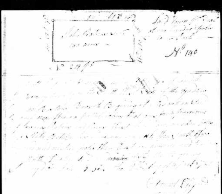
On March 2, 1780, John Robins recieved a 150 acre Grant, Warrant 140, issued by Benjamin Baird, on the SW side of the Yadkin River and on Boston's Branch. The border began at a Red Oak along the branch near where a path crosses "from Parmours towards Robins'. It was surveyed 5 years later, 1785, by Edmund Lilly. William Ramsey, whom I just mentioned, and John Robbins, Jr. were chain carriers. John Jr. would have been in his teens at this point. The grant, pictured below, is difficult to read, #342, issued August 9, 1786.
In all honesty, there were not that many grants given for Boston's Branch. It must have been a small stream. The other one dated 1780 was that of William Baird, for 200 acres, Warrant 292 issued on June 26, by BenjaminBaird to William Baird on Boston's Branch on the Waters of Long Creek and includes AndrewBankston's or John Kelly's improvement. It was surveyed in 1785 by Mark Allen, on the SW side of the Yadkin River between Deep Creek and Long Creek and began at a pine on Parmer's line. Zachariah Hogon and Mark Allen were chain carriers. Grant 422 issued Nov. 26, 1789
There's that name, 'Parmer" or 'Parmour' again, as well as Baird. Another intestesting thing is the part where it includes the improvements of Andrew Bankston or John Kelly. John Robbins Sr. must have gotten anscious after his young son, John Jr. was drafted into service during the Revolutionary War, and hired a substitute named William Bankston to take his place. My bets would be that William Bankston was related somehow to the above mentioned Andrew Bankston. This was a family that did not remain in the area. A quick search of just Land Grants shows grants being in 1779, the year Montgomery was cut from Anson, and the names of Jacob, Lawrence, Daniel and Andrew Bankston, with Andrew recieving a whopping 5 grants, all located in what would become Stanly County. Switch the search to Anson and I found 5 more for Andrew, beginning in 1775, all on the West Side of the Yadkin, the first on the east side of the Long Branch of theYadkin River, two on the Middle Fork of Mountain Creek and two on Deep Creek, which is in modern Anson.
Another interesting deed, not on Boston Branch, but included here because of the date, was a 150 acre grant received of Henry 'Munger' (Mounger) in 1782 on the Northeast side of Bear Creek, and includes a springhead at the head of Little Creek, beginning at a pine, whereinThomas Reynolds and John Robins were chain carriers. This must have been John Jr. as John Sr. was declared an invalid in the 1782 tax records.
Inspecting a terrain map, Little Creek seems to be born off the runoff from a ridge to the east of Tyson Road and begins near Western Road, fed by hills along the side of it. Henry Mounger, like Benjamin Baird, was an early land prospector. He was continually cutting grants from his larger tracts.
Next up, on Christmas Eve, 1785 was Hezekiah Dollarhide,shown above,recieving a 100 acre grant from John Crump on Boston's Branch of Long Creek and included 'young John Robbins improvement'. Grant 403 was issued on August 7, 1787 and John Pamer and Edmund Lilly, Jr. were chain carriers. It appears John Jr. was clearing and cultivating this land before Hezekiah Dollarhide recieved the grant.
Two years later, in 1787, Hezekiah Dollarhide recieved a second grant, to property on Little River in Randolph County, NC, as an assignee of John Knight. There were two Hezekiah Dollarhides, one born in 1745 and the other in 1783. This would have had to be Hezekiah Sr. The family left Randolph County before 1820 and settled in Wayne County, Indiana. He died there after 1830.
Hezekiah Dollarhide
Home in 1820 (City, County, State)
Wayne, Indiana
Enumeration Date
August 7, 1820
Free White Persons - Males - 45 and over
1
Free White Persons - Females - 16 thru 25
1
Free White Persons - Females - 45 and over
1
Number of Persons - Engaged in Agriculture
1
Free White Persons - Over 25
2
Total Free White Persons
3
Total All Persons - White, Slaves, Colored, Other
3
When John Robbins Jr. stated in his pension application that he had lived in Indiana for awhile after his service, I wondered if that had had anything to do with Hezekiah Dollarhide, or if he had travelled with him.
Then came the Smiths. On October 3, 1800, warrant 5391 was issued by John Neal to "Sherrid" Smith for 150 acres that began at Sherrod Smiths (also seen as Sherwood) own corner tree on Boston's Branch of Long Creek, surveyed on May 4, 1801 by Thomas Cotton. It was on the southwest side of the Yadkin River, on Bostons' Branch of Long Creek, and joined the property of Asa Smith, 'near' Castle. Sherrod and Asa Smith were the chain carriers. It then stated that on November 24, 1801 Sherrod Smith paid purchase money for 150 acres in entry #5391, signed by the comptroller, grant 1785.
The very next grant, No 5392, was to the aforementioned Asa Smith. While his property was not on Boston Branch, I've included it because he had property that bordered that of Sherrod Smith that was on Boston's Branch.
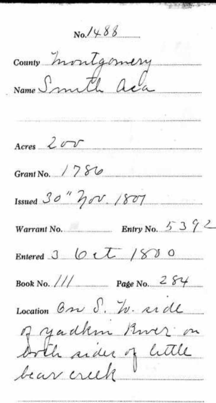
Asa Smith recieved a grant for 200 acres on each side of "Bear" Creek, that was SW of the Yadkin River and on both sides of Little Bear Creek bordering a post oak in his own 100 acre tract. Richard Green and Sherrod Smith were chain carriers.
I kept looking for a spot where a branch off off Long Creek might lend itself to allowing joinng properties close enough to touch a 150 acres property that straddled Little Bear Creek.
Asa Smith owned several properties. The below deed has an interesting northern border that looks very difficult to plat. This was the one that straddled Little Bear Creek.
But we're not done with the Smiths, oh no!
In 1814, Phillip Smith received a warrant of 100 acres, issued on June 8 by Will Stone, on the waters of Long Creek, on Boston's Branch, joining the lands of Sherrod Smith and Andrew Bankston, Surveyed in 1814 by David Cochran on the waters of Long Creek, the border beginning at a pine in 'Sharwood' Smith's line, joined Phillips own line and that of Lloyd Rowland. Sherwood and Phillip Smith were chain carriers.
Boston's branch was becoming a regular little Smithville.
And above is Phillip Smiths plat of land, a simple rectangle with an anchor. I am not able to tell which side of it was on Boston's Branch, and where it met the property of Sherwood Smith or Andrew Bankston. My best guess would be that 'toe' was sticking in the creek.
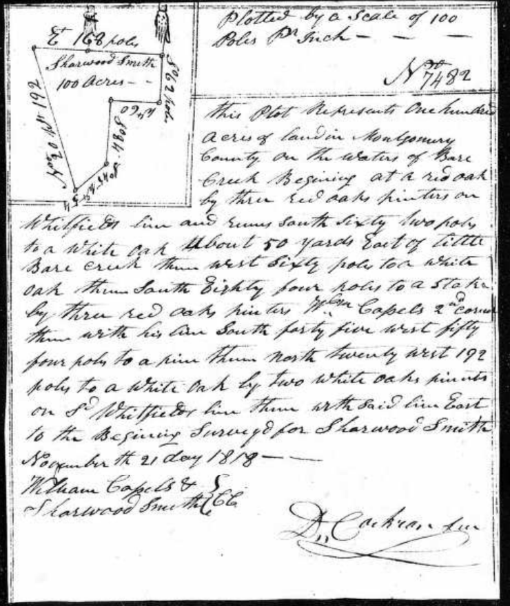
Then below, we have Sherwood Smith's land on Bear Creek, meeting Whitfields line and was 50 yards east of Little Bear Creek It also met the property of William Capel and William Capel and 'Sherwood' Smith were the chain carriers
I keep coming back to this area of the county, and these creeks and roads, flipping them one way or another, and looking at the current county GIS maps to see if any shapes look familiar. As of yet, this puzzle remains scattered on the table in so many pieces.
Asa Smith owned another tract which bordered the property of Brittain Chappel. I begin to notice that some of these mulitiple tracts to the same individuals were not that close together. This wasn't a small farmer adding to his already owned property widen his purvey, this seemed more like an investor, grabbing up property, perhaps as people moved on, and maybe capitalizing by renting it out, but they certainily were not driving that oxteam up a dirt road for 10 miles every day to plow their second field.
Asa Smiths grant that neighbored Brittain Chappel named Elijah and David Smith as chain carriers. This was certainly a family venture.
The Smiths seemed to have a bit of an enclave on, or near, Bostons Branch, so it is time to take a close look at who they were.
Asa Smith was counted in the 1790, 1800 and 1810 census records of Montgomery County, North Carolina.
He recieved several land grants in Montgomery County. The first, Grant Number 1786, in 1801, was located on the Southwest side of the Yadkin River, on both sides of Little Bear Creek. This grant of 200 acres included Sherrod Smith and Richard Green as chain carriers.
His second grant, shown above. 7629, dated 1817, joined the property of Brittain Chappel, joined his own property on Long Creek.
His third grant, Number 2529, Dated December 5, 1818, was on the waters of Long Creek. Elijah and David Smith were chain carriers.
Asa may have removed to Tennesee. I can not be certain. I am also not certain of his relationship with Sherrod, or Sherwood Smith, but the chances are pretty good that they were related in some way, the most likely being brothers, as they were not parent/child. This is just a possibility.
Sherwood or Sherrod Smith, is a little better known. He was born in Viriginia and was also in Montgomery County, North Carolina by the 1790 census, but did not stay here. He married his wife, Faith "Faithy" Holmes in Mecklenburg County, Virginia on December 21, 1786. By 1830, he was in Carroll County, Tennesee and he is in Willamson County, Tennesee in 1840 and 1850. He was also on the 1816 petition concerning the county courthouse location, along with his sons, Phillip and Sherwood Jr.
Will of Sherwood Smith
Sherwood Smith died in Williamson County, Tennessee in 1851 and left a will., menitioning two of his sons living in Illinois. One of them was Phillip.
Name
Philip Smith
Gender
Male
Birth Date
1780
Birth Place
Montgomery County, North Carolina, United States of Jo
Death Date
14 Sep 1860
Death Place
Blueville, Christian County, Illinois, United States of America
Cemetery
Taylor Cemetery
Burial or Cremation Place
Riverton, Sangamon County, Illinois, United States of America
Phillip Smith was the oldest son of Sherrod Smith. He was born in Montgomery County, North Carolina in 1780 and married Nancy Cooper, daughter of John and Elizabeth Carter Cooper. He first shows up in the 1810 census of Montgomery County, on the West Side of the Pee Dee River and recieves his grant on Boston's Branch of Long Creek in 1814. By 1820, he was in Sangamo, Madison County, Illinois, where he chose to raise his family. He died there in 1860.
In 1810, however, the Smiths were in Montgomery County, North Carolina. The above list is the census page that Sherwood, Asa and Phillip Smith all appear on. The complete list is a little difficult to read in spots and since I am familiar with most of these names, I will retype it here:
James Casles (Cassels/ Castles)
Sherwood Smith (also seen as Sherrod)
David Rowland
Asa Smith
Richard Greene (Chain Carrier mentioned in Asa's grant)
Daniel McLester
Andrew Bankston (also mentioned in several of the above deeds. Land bordered Smith land on Boston's branch)
John Palmer (see * note below. Very important)
Robert Stokes
Ambrose Stokes
Allen Stokes
James Coleman
Phillip Smith (son of Sherwood, on Bostons' Branch)
Henry Carter
Samuel Mann
Henry Mann
Solomon Holt
Malachi Mann
Richard Stokes, or Stoker
I thought WOW!, I know these people! No, I don't literally know them. I'm not that old. I am familiar with these names having came across them in prior research adventures. How's that?
*Note: Now I know who "John Parmer" or "Parmour" was, the dude with the path. Palmer, not Parmer. Not only do I know him, somewhere in my dna are pieces that John Palmer shared. He's my 5th Great Grandfather. John Palmer (1746- 1817) was born in Maryland and the son of Thomas Palmer and Susanna Hunt. The Palmers were a very, very old New England family. He married Janice Tamer and settled along the upper part of Long Creek in what is now Stanly County, and was then, Montgomery. Henry Davis, son of Job Davis, whom this blog is named for, married Martha Palmer, a granddaughter of John Palmer, as his second wife, and became my third Great Grandparents. This was at the inception of the new county of Stanly and Henry had moved from the Rocky River and purchased land on Cloverfork Creek, to be closer to his business in helping found the infant town of Albemarle.
James and Martha Atkins Palmer
I don't know exactly where John Palmer lived, but I do know exactly where his son James Palmer and wife, Patsy Atkins Palmer lived, and where Martha Palmer Davis had grown up. I also know the general location of where the Holts and Manns, listed at the bottom of the page, lived.
Now, census takers used a methodology of taking count that I am not familiar with, but I do know they didn't count one family, and then ride 15 miles in another direction to count the next. The people listed were centrically located near enough to each other. Given, the population was sparse and neighbors could be far more than " hollering distance" away. Still, the neighborhood is suggesting a location more along the northern part of Long Creek, an entirely different location than I was looking at.
Could Boston Branch have been, literally, in my own backyard?
Plats assembled by George Thomas
I have a distant cousin on the Burris side who has an inate talent for assembling these little snippets of plats, and had already some of the Smiths. Now we have a visual of where Phillip Smith's little point of land belonged.
Now I have new names to cut out and stare at like so many pieces of a jigsaw, and try to place them on a map.
And we are back to John Robbins barely visible grant on Boston's Branch. While in Anson County, I can find mention of properties adjoining that of John Robbins into the 1830's, long after I expect John Robbins Sr. was deceased, the latest mention of John Robbins, which I expect was John the Younger, in Montgomery County, was in 1814.
I will attempt to track his course from Montgomery County, North Carolina into Tennesee and Indiana and finally, to Spadra, Johnson County, Arkansas.
Which Branch was Boston's Branch and where did it go? Did it dry up and just disappear from record, or did it just gain a new name? Why was it called "Boston" in the first place? Did one of the early settlers upon it come from Boston? I keep looking at Gilberts Creek, shown on the left side of the map. In other deeds and records, the Robbins were very involved with a family of Gilberts, both in Montgomery County and in Anson. John Gilbert, Jesse Gilbert, Samson Gilbert, for the most part. I've found in other families that I've delved into that when two families seem particularly intwined and involved in one anothers business, that they are in fact, one family, intermarried and connected, usually, generationally, sometimes in several ways.
William Ramsey is another man I want to look into. Maybe, just maybe, there was a connection to Stark or to John Ramsey the elder, (as Starkey had a son named John). Another little tidbit, is that signature of John the Younger, (and of even a younger John Robbins who appears to be John III) as Jno (squiggly) Robbins Jr. The squiggly is not a J, as it looks nothing like a J. I believe it might be an I.
The location of Boston' branch has not been acertained. I'm tossing this missive into the metasphere to see if anyone out there has any more information about it. Was it renamed, or did it dry up due to changes in the environment? Was it on the northern end or southern end of Long Creek? Only just a handfull of men had grants located on it, so it must have been a small, short branch. The only thing I am sure of, Boston Branch was nowhere near Cucumber Creek.
When the jigsaw is assembled, I will be back. I will be looking at those men in the 1810 census located nearest to the known occupants along Boston Branch. Until then, I'm going to Clarksville.